


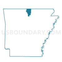
Voting District 3-2, Baxter County, Arkansas
About
Outline

Summary
| Unique Area Identifier | 525882 |
| Name | Voting District 3-2 |
| County | Baxter County |
| State | Arkansas |
| Area (square miles) | 26.35 |
| Land Area (square miles) | 23.27 |
| Water Area (square miles) | 3.09 |
| % of Land Area | 88.28 |
| % of Water Area | 11.72 |
| Latitude of the Internal Point | 36.39030770 |
| Longtitude of the Internal Point | -92.18803120 |
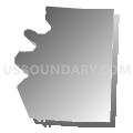
Maps


Graphs
Select a template below for downloading or customizing gragh for Voting District 3-2, Baxter County, Arkansas


Neighbors
Neighoring Voting District (by Name) Neighboring Voting District on the Map
- Voting District 3-1, Baxter County, AR
- Voting District 3-3, Baxter County, AR
- Voting District 3-4, Baxter County, AR
- Big Creek Voting District, Fulton County, AR
- Vidette Bayou Voting District, Fulton County, AR
Top 10 Neighboring County Subdivision (by Population) Neighboring County Subdivision on the Map
- Mill township, Baxter County, AR (2,478)
- Union township, Baxter County, AR (1,856)
- Vidette township, Fulton County, AR (467)
- Big Creek township, Fulton County, AR (428)
- Bayou township, Baxter County, AR (360)
Top 10 Neighboring Unified School District (by Population) Neighboring Unified School District on the Map
Top 10 Neighboring State Legislative District Lower Chamber (by Population) Neighboring State Legislative District Lower Chamber on the Map
Top 10 Neighboring State Legislative District Upper Chamber (by Population) Neighboring State Legislative District Upper Chamber on the Map
Top 10 Neighboring 111th Congressional District (by Population) Neighboring 111th Congressional District on the Map
Top 10 Neighboring Census Tract (by Population) Neighboring Census Tract on the Map
- Census Tract 5502, Fulton County, AR (6,287)
- Census Tract 9506, Baxter County, AR (3,816)
- Census Tract 9507, Baxter County, AR (3,445)